Every project starts with what the register says.
Parcelia resolves a Swiss address down to its parcel and compiles everything the official registers say about it — building, zone, building regulations, restrictions, environment — into a readable file, with the provenance of every field.
Listing a property, appraising a development, planning construction, buying: agencies, architects, developers, notaries and owners all start from the same factual base, for any Swiss address.
The document
This is what you download.
A seven-page A4 PDF, typeset for paper: every line carries its source and its status, every regulation is clickable. These images are the real first pages of the file compiled for Rue de Médran 2 in Verbier.
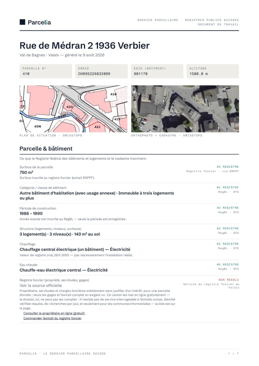
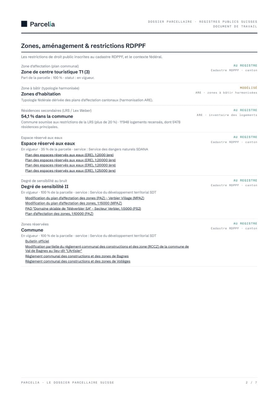
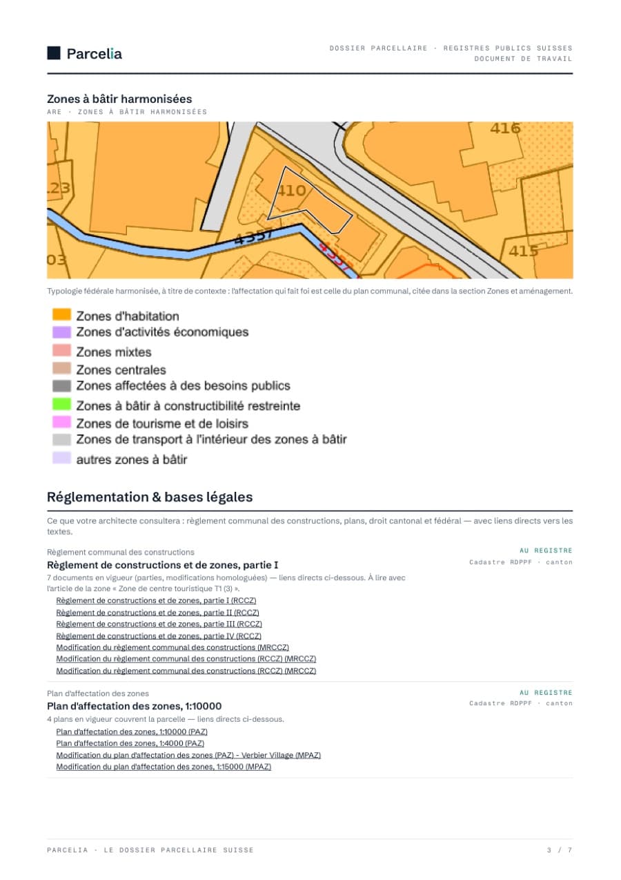
1 / 7 · Identifiers, maps, building
01 · Provenance first
No valuation, no black box. Four honest statuses.
Every field in the file names its source and shows exactly one of four statuses — so that an owner, an architect, a buyer, a bank or a notary sees at a glance what is established and what is not.
Confirmed in an official Swiss register (RBD, cadastre, cantonal geoportal). Direct source, cited on the field.
The register was queried and holds nothing for this parcel. The absence is documented — it carries as much weight as an entry.
Derived from a model or a federal API (public transport access, solar potential). Real, but not a register entry: to be verified.
A special case was encountered (missing cantonal data, ambiguous response). Reported honestly, never dropped in silence.
02 · What a file covers
From the address to the complete file
- 01
Official identifiers
Parcel (EGRID), building (EGID), municipality, elevation: the keys that connect the parcel to every register.
- 02
Building — RBD
Year of construction, category, dwellings, floors, heating and energy source, as recorded in the Federal Register of Buildings and Dwellings.
- 03
Zoning & planning
Building zone (ARE / canton), the municipality's second-home rate (Second Homes Act / Lex Weber): decisive in every Swiss tourist municipality.
- 04
Regulations & legal bases
The municipal building regulations applying to the parcel, the land-use plan, cantonal and federal law — every text linked in plain sight: what the architect opens before drawing.
- 05
Protection & heritage
Protected built sites (ISOS), landscapes of national importance (BLN), historical routes (IVS), cultural property (PCP): the federal inventories touching the parcel or its surroundings.
- 06
Environment & natural hazards
Polluted sites, noise, water protection, and the canton's natural hazard maps — floods, landslides, rockfall, avalanches — with a link to the official PLR cadastre extract.
- 07
Modelled context
Public transport accessibility (ARE) and roof solar potential (SFOE), clearly separated from register values.
In the field
One file, several uses.
- Before listing a property — check zone, building and restrictions before setting the strategy, spot sensitive points early (second homes, hazards, polluted sites), then attach the file to the listing.
- For a development appraisal — know what the zone permits, which municipal regulations apply and which public-law restrictions encumber the land, before committing to study costs.
- With the architect — the building regulations, the land-use plan and the parcel's legal bases, linked in plain sight to their full text.
- At the notary or the bank — a working document where every statement cites its register.
03 · Frequently asked questions
What is this file for?+
For understanding a parcel before deciding. Before a sale, it shows what the public registers say about the property — zone, building, restrictions, second homes — and then accompanies the listing. For a development appraisal or a construction project, it brings together the land-use zone, the municipal building regulations and the public-law restrictions encumbering the land. In every case, a buyer, a notary or a bank sees at a glance what is established and what remains to be verified.
Can I search by parcel number?+
Yes. Type the number alone (“410”) and Parcelia offers the Swiss municipalities where that number exists — each with its canton and EGRID — and tells you how many there are in total; add the municipality (“Val de Bagnes 410”, “Zürich AA4421”) to go straight there. Useful when you start from a land register extract, a plan or a listing that gives no address — undeveloped land often has none.
Where does the data come from?+
Exclusively from Swiss public registers and geoservices: Federal Register of Buildings and Dwellings (RBD/FSO), official cadastral survey (swisstopo), building zones and public transport access (ARE), solar potential (SFOE), environmental registers (FOEN), cantonal PLR cadastre. Every field cites its source.
Is this a valuation?+
No. No valuation, no black box. The file reports the register, nothing but the register. That is precisely what makes it useful upstream: of a valuation, a feasibility study or a preliminary design.
Does the file replace the land register extract?+
No. Ownership, easements and land charges belong to the land register, which this file does not compile — but they are not closed: anyone may obtain them for a given parcel without justifying an interest, and several cantons publish them online. Only mortgages and the full extract require a legitimate interest. The file says so, points to the canton's office, and links to the official PLR cadastre extract where one exists.
Does the file catch reserved planning zones?+
Yes. When a reserved planning zone — municipal or cantonal — is published in the PLR cadastre, the file shows it as a restriction in force, with the share of the parcel affected and the responsible office. A parcel can sit in a building zone and still be frozen by a planning zone: the file shows both, on the same page, each with its source.
How much does a file cost?+
During the launch period the complete file is entirely free — no account, printable PDF.
READY TO EXAMINE AN ADDRESS?